I have mentioned in other blog posts that I am obsessed with the Bonneville Flood. When I discovered that the Riverwalk was to be led by Geoscience Professor Paul Link and he would be discussing/pointing out geology related to the flood I HAD to go. As expected it was very interesting.
This was the same morning as the homecoming parade. So after the fruitless attempt to help with the library float, I dashed over to Mocha Java for a bit of Chai to warm me up for the second morning walk. Somehow I managed to get there before Nick and Barkley. Barkley loved hearing about the flood, or maybe he just liked being outside with so many people.
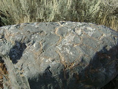
This is a picture of one of the many boulders that the Bonneville flood ripped out of the basalt lava, tumbled till smooth and deposited all over Pocatello. Dig anywhere in downtown Pocatello and you find monstrous black boulders. Apparently, these are much coveted for landscaping...
My other entries on the Bonneville flood are here:
http://jsemenza.blogspot.com/2006/04/geology-lake-bonneville-timeline.html
http://jsemenza.blogspot.com/2006/04/geology-lake-bonneville.html
After that walk, we returned the doggie to the house and went to the baglery for lunch. A pleasant day, I walked 5 miles before lunch.
Showing posts with label lake bonneville. Show all posts
Showing posts with label lake bonneville. Show all posts
Tuesday, October 21, 2008
Sunday, April 16, 2006
Geology: Lake Bonneville - Timeline
Nick said I needed to add a timeline to the Bonneville Flood entry, so here it is.
The Timeline Addendum:
Lake Stansbury 24,400 - 20,000
The waters of the surrounding ranges began to collect in the basin. Apparently there was a climate change of some kind that held the level stable for approximately 3000 years.
Lake Bonneville 18,000 - 14,500
The basin began collecting more water. With no outlet it grew and grew until it reached the rim of the Red Rock Pass and began overflowing as a small stream.
Flood 14,500
Catastrophic erosion of the softer layers of rock at Red Rock Pass allowed the waters of Lake Bonneville to flood through Pocatello and on into the Snake River.
Lake Provo 14,500 - 13,500
Outflow through the Red Rock Pass stabilized as erosion came to a screeching almost standstill. Lake Provo was stabilized until the end of the last major ice age. The reduced flow of water into the lake caused the lake to retreat.
Lake Gilbert 11,000 - 10,000
Resurgence in water flowing into the basin created this level, before finally shrinking to the Great Salt Lake level.
Great Salt Lake Present
The Great Salt Lake is still in a basin. It is no longer large enough to flow out through the Red Rock Pass. Water can only escape through evaporation.
See earlier post on Lake Bonneville for Internet Resources
Friday, April 14, 2006
Geology: Lake Bonneville
Lake Bonneville
Lake Bonneville was sited in the Basin and Range Province. It is called the Basin and Range province because water does not leave the Basins, which are bounded by Ranges. There’s no outlet such as the Snake River for the water to use to get to the ocean. Lake Bonneville was nestled all snug in its Basin filling valleys and flats over a large portion of Northern and Western Utah. The only outlet for the water was a small stream that flowed North into Idaho. Lake Bonneville retained its level until the stream eroded through the harder rocks into soft rocks. Once the stream hit the softer rocks it eroded quickly and the dam that had retained so much of Lake Bonneville was broken. Water poured through this gap for months. It flooded North through Downey, the Portneuf Gap, Pocatello and on into the Snake River. The volume of water was about 600 cubic miles in total. The maximum discharge exceeded the total fresh water flowing into all the oceans of the earth today. Another way to perceive the flow is to compare it to the Amazon River. The Lake Bonneville flood flowed at 3 times the rate of the Amazon. The Snake River, engorged by this additional water raced to the sea. Months later, Lake Bonneville was no more. In its place was the new Lake Provo. The little stream heading into Idaho had hit harder rocks again. It stabilized Lake Provo at its new level approximately 350 feet below the Lake Bonneville mark. If the climate were to change and water rained down on Utah, Lake Provo could refill.
Take a look at the map here:
http://geology.utah.gov/online/PI-39/pi39pg01.htm
It's really hard to get a grasp on how large the lake really was. To really get an idea, look for Logan. North of Logan is Red Rock Pass then find Provo, Wendover (over in Nevada) and South to Milford. This lake was HUGE.
Other Interesting Lake Bonneville Web Sites:
Lake Bonneville -- Digital Atlas of Idaho Project
http://imnh.isu.edu/digitalatlas/hydr/lkbflood/lbfdex.htm
http://imnh.isu.edu/digitalatlas/geog/rrt/part2/26.htm
http://imnh.isu.edu/digitalatlas/hydr/lkbflood/lbf.htm
Final Report - GIS 18 (Utah State University, College of Natural Resources)
http://www.nr.usu.edu/Geography-Department/rsgis/Projects/RSGIA96/gis18/gis18.html
History of Lake Bonneville (University of Houston)
http://geoinfo.geosc.uh.edu/VR/idaho/index.htm
I'm working on a field trip guide for Nick and I to use to really understand the scope of Lake Bonneville and the effects of the flood.
Jenny
Subscribe to:
Posts (Atom)